
 Latest images
Missing data points
2 posters
![]()
 Missing data points
![]() by Jim A. Thu Sep 24, 2015 11:10 am
by Jim A. Thu Sep 24, 2015 11:10 am
I am missing some map data along the base map's shoreline. The base map's shoreline is off by several hundred feed. I'm trying to post a picture of the issue but I can't post the image from the computer. I'll try in the reply screen.
Last edited by Jim A. on Mon Oct 12, 2015 9:41 am; edited 2 times in total (Reason for editing : Not really a valid question. Trying another way.)
Jim A.- Posts : 12
Join date : 2015-09-06
![]()
![]()
Re: Missing data points
![]() by Jim A. Sat Oct 10, 2015 10:44 am
by Jim A. Sat Oct 10, 2015 10:44 am
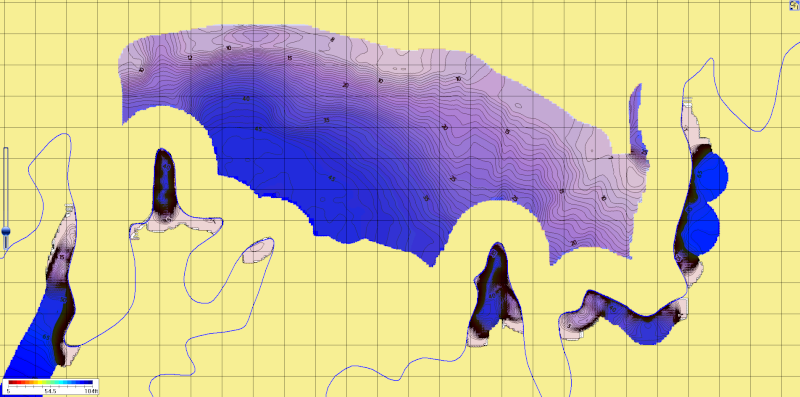
Got it, here's the picture I see with the missing data.
Last edited by Jim A. on Sat Oct 10, 2015 10:46 am; edited 1 time in total
Jim A.- Posts : 12
Join date : 2015-09-06
![]()
![]()
Re: Missing data points
![]() by Jim A. Sat Oct 10, 2015 10:57 am
by Jim A. Sat Oct 10, 2015 10:57 am
If you start towards the top right on the grid (fifth line from the right and four lines down) and follow it along, you can see this missing data. The base map's shore line is the blue line, as you can see it is way off) the real shoreline is toward the top of the picture. It almost looks like someone used a paint program and erased about 100 feet of information between the incorrect shoreline and the real shoreline.
Any ideas?
Any ideas?
Jim A.- Posts : 12
Join date : 2015-09-06
![]()
![]()
Re: Missing data points
![]() by CamoHunter Thu Oct 15, 2015 9:58 am
by CamoHunter Thu Oct 15, 2015 9:58 am
I can't see the pictures right now, I'll try to take a look when I get home.
CamoHunter- Posts : 79
Join date : 2015-01-21
![]()
![]()
Re: Missing data points
![]() by CamoHunter Thu Oct 15, 2015 9:48 pm
by CamoHunter Thu Oct 15, 2015 9:48 pm
If you want the issue fixed, you will need to create your own custom shoreline for that area.
The reason it is doing what it is, is because shoreline data is defined as having 'water to the left' or 'water to the right' of the shoreline line. That is why you see a section of water missing on one side of the shoreline, but on the other side is has water going right to the shore. So, in this case, the shoreline is defined as having water to that side of the shoreline. That is also why you see really tight contour lines next to the shore on that side, because it assumes the shoreline is 0.0ft depth. So your closest depth finder data point is a certain depth, and the shoreline is 0.0ft, so it figures there is a really steep drop off next to shore.
All of their basemap shoreline data was pulled from GIS data for waterbodies. As you've seen, those are not always accurate to the actual shoreline.
Since you're going to need to create a custom shoreline in order to fix this, you may find my tutorial on creating custom shoreline data useful.
CamoHunter- Posts : 79
Join date : 2015-01-21
![]()
![]()
![]()

 Similar topics
» Autochart Tutorial - How to Remove/Edit Bad Data Points
» AutoChart Pro conversion error and missing data
» Missing Autochart Live files
» I cant seem to get all my data to fit in one map.
» Submit Map Data
» AutoChart Pro conversion error and missing data
» Missing Autochart Live files
» I cant seem to get all my data to fit in one map.
» Submit Map Data
Permissions in this forum:
You cannot reply to topics in this forum|
|
|